For Eric Fischer, it all started with a trip to the University of Chicago library. It was, for him, a typical visit. He was there to research the origins of the modern keyboard layout. Not for a class, or even a master’s thesis, but just to know.
“Here’s one of these artifacts of life that has a very arbitrary arrangement, and somebody made a decision for it to get this way,” he explains. While trying to solve that mystery, his eyes wandered.
Shelved across from the books on typewriters sat volumes about public transit. He opened one to find old maps and photos of the Union Loop portion of Chicago’s “L” train, and was immediately captivated by the system’s legacy. Later that year, when the transit system celebrated its centennial, Fischer ran to the nearest bookstore to special-order the hefty commemorative book. “I just had to get a copy of this thing,” he says.
After that he was hooked on maps — for Chicago, where he went to college; for the Mission, where he lived for six years; and nowadays for the world.
The 37-year-old, who works for a technology company, has become increasingly well-known for his hobby as a creator of maps and curator of illuminating, often quirky, bits of transit history.
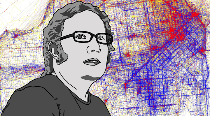
Fischer’s maps have been called art. People who see them on Flickr comment on their beauty, marvel at their intricacy. Many ask for prints to decorate their walls.
These maps transform real-time Muni bus arrival data into a dynamic time lapse of marching ants, a birds-eye view of a day in the life of San Francisco transit. They weave a world’s worth of geo-tagged photo data, which detail the time, date and location of photos taken with location-aware cameras, into digital streams of red, yellow and blue, cleverly laid over city streets to sift the tourists from the locals in a given place. They plot census data into colorful blocks showing the stark outlines of racial divide in America’s largest cities.

“People always want to know — when did you do this stuff, why did you do it, what does it mean?” says Fischer, sitting outside Gaylord’s Cafe on Piedmont Avenue in Oakland. “I wish I had a good answer for them.”
Why turn innocuous bits of data into striking images?
Why not?
“Once I heard there was the location data available for NextBus, of course I’m going to make a map of it. It’s inevitable; there’s nothing else that could be done,” he says without a hint of irony.

His plots of demographic data from the 2000 census have made the rounds in the blogosphere, finding their way to the Boston Globe and Time’s website.
His Geotagger’s World Atlas, a visual where’s-where of human interest showing the concentration of photos taken of various spots within a city, have made data visualization geeks nationwide, and even the Wall Street Journal, take notice.
Though the buzz surrounding Fischer’s work is a recent development — he started his Flickr account in 2008 — this kind of deliberate data tinkering has been a lifelong practice.
At the age of 10, Fischer was writing rudimentary video games on his first computer — “the same kind of stuff any 5th-grader would do, I guess.” In college he spent hours in the library researching everything from the origins of the telegraph to the minutes of computer conferences from the 1950s.
He roamed, following his whims through the library aisles, and came to know the system by heart (computer books can be filed under electrical engineering, Library of Congress subclass TK, he explains, unless, of course they’re under HF, business equipment). Often, it was the history of technology that captured his curiosity.
Before his Flickr days, Fischer’s collection was analog. In Chicago he collected reams of old photos, transit maps and plans, pages photocopied from history books, and other papers of interest, which he organized into spiral-bound books at a local copy shop.
This practice continued after he chased the dot-com boom to San Francisco, straight to an apartment at 18th and Valencia and a series of gigs at tech start-ups. Those who follow Fischer now, including JohnnyO of Burrito Justice, Jeff Hunt of Muni Diaries and Mission Loc@l, know him just as much for his penchant for digging up the relics of local history as for his maps.
He is also a finder of all things vintage Bay Area transit, from outdated Muni maps and long-forgotten BART plaza sketches to abandoned plans for San Francisco freeways and an eyebrow-raising BART connection over the Golden Gate Bridge that never came to pass.
On any given weekend, Fischer might get cozy on the sixth floor of the city’s Main library, where the San Francisco History Center is located. Or, if he feels like being outside, he’ll hunt for weathered maps and retro electronics at Thrift Town. Another favorite place — the main stacks of the UC Berkeley library.
From these urban digs, Fischer has posted more than 3,000 images to Flickr since 2008. This year he’s averaged about 200 posts a month. Some are maps he’s created, some photos he’s taken of street signs and roadways on his weekend jaunts. Many more are historical maps and documents scanned from library books or snagged on eBay.

“Eric’s Flickr stream is, bar none, the best I’ve seen, from a historical and urban-planning perspective,” wrote Jeff Hunt of Muni Diaries in an e-mail to Mission Loc@l. “He’s relentless in his production.”
Fischer now lives in Oakland, commutes daily to his job in Mountain View and spends his weekends researching and exploring in San Francisco. “My life makes no geographic sense, basically,” he says.
It’s ironic, considering he’s spent his adult life trying to make sense of urban geography. “This has been a long obsession of trying to figure out what makes some places work and some places not.”
What works? San Francisco, he says. “It’s one of the few places where for the most part it’s easier to walk places than to drive.” And what doesn’t work? “Des Moines, where you’ve got pedestrian bridges everywhere between buildings so that nobody ever actually goes outside.”
And then there’s the great paradox: “Why does the Las Vegas strip work in spite of itself?” he wonders, citing the large numbers of pedestrians in spite of its inhospitable streetscapes. Could it have anything to do with public drinking? “Maybe,” he shrugs.
For Fischer, the research gives him a visceral relationship with public space. “There are some places that you go that feel dead and some places that feel alive,” he struggles to explain. “Alive places have a little bit of tension to them; there’s not quite enough space for everything that you might want to fit.”
“San Francisco is tight, people actually walk there, it’s densely built, it’s got stuff going on.”
It could have been different, says Fischer. He often finds plans that, he says, are rightfully buried.
Recently, for example, Fischer uncovered sketches from a 1966 urban design study that imagined the 16th Street and 24th Street BART plazas as large, landscaped areas surrounded by highrises.

Complete with pedestrian walkways between complexes for housing, office space and parking, it was an eerie replica of a Financial District streetscape. “There must have been people who really thought, ‘Wouldn’t it be cool to live in a gigantic concrete slab and have bridges to take you to Mission Dolores?’” he says, dumbfounded.
One other such vision saw the city as a sprawling network of freeways, including a proposed Mission Freeway along South Van Ness that would have cut through the heart of San Francisco. Known as the 1948 Trafficways proposal, it was fiercely opposed by city residents in what came to be dubbed the San Francisco Freeway Revolt.
“San Francisco stands out in legend as the place that resisted the freeways,” says Fischer, who admits he’s been sitting on the domain name trafficways.org for years, hoping to post his collection of the freeway plans some day.
Fischer credits the movement for San Francisco’s unique characteristics as a 19th-century city — “cities that were built to be walked in, and where vehicles were kind of an afterthought.”
And Fischer should know: He does a lot of walking. Two hundred miles and counting, to be exact.
For several years, Fischer has been working toward the goal of walking every street in San Francisco. A Google map tracks his progress. According to the California Natural Resources Agency, he has another 691.6 miles to go.
For his part, Fischer doesn’t think he’s finished, and is not sure he ever will be — with map-making, researching or even walking.
“I want to understand how the world fits together. Every little bit of it gives another tiny clue. I’m never going to understand the world on the quantum mechanics level, but as far as what places people go and how they get there, I can stand a chance of getting on top of that.”
Great article! I drool every time I see one of Eric’s old transit/city planning documents or one of his fantastic new maps. He’s a great reminder of what could have been, the mistakes we’ve made, and the ones we’ve avoided, and will hopefully help keep us on the right track.
I’m glad he brought up Vegas. I was there about a year ago for the first (and probably last) time, and was shocked at how many people were out on the sidewalks of the main strip despite its incredibly unfriendly pedestrian design elements (or lack thereof). It has the potential to be so much greater, but my guess is they’d rather keep it as unfriendly as possible outside, in order to keep people spending all their money inside.